Understanding What's Beneath Your Land
“This survey has no effect on landowners’ mineral rights, water rights, or surface ownership; it is a data-collection process only.”
Silverthorne Seismic II is conducting a 3D seismic survey in the Redtown project area near Lufkin, Texas. This survey is an important step in understanding the structural geologic features beneath the surface of our region. Modern 3D seismic surveys use sound wave technology and geophysics to create detailed subsurface maps, helping energy companies make better-informed decisions while minimizing unnecessary ground disturbance. We are committed to operating responsibly, respectfully, and transparently throughout every phase of this project.
Our Commitment
To Landowners and the Community
We understand that having a survey and geophysical crews on or near your property raises real questions about access, your rights, and the potential for any impact to your land. Our team is here to answer every one of those questions.
Before any activity takes place on permitted properties, our representatives at Goldstar Land Services will make direct contact with surface owners to explain the process, address concerns, and ensure all agreements are clearly understood. Your land, your peace of mind, and your rights matter to us, and we take that seriously.
Your Questions, Answered
Frequently Asked Questions
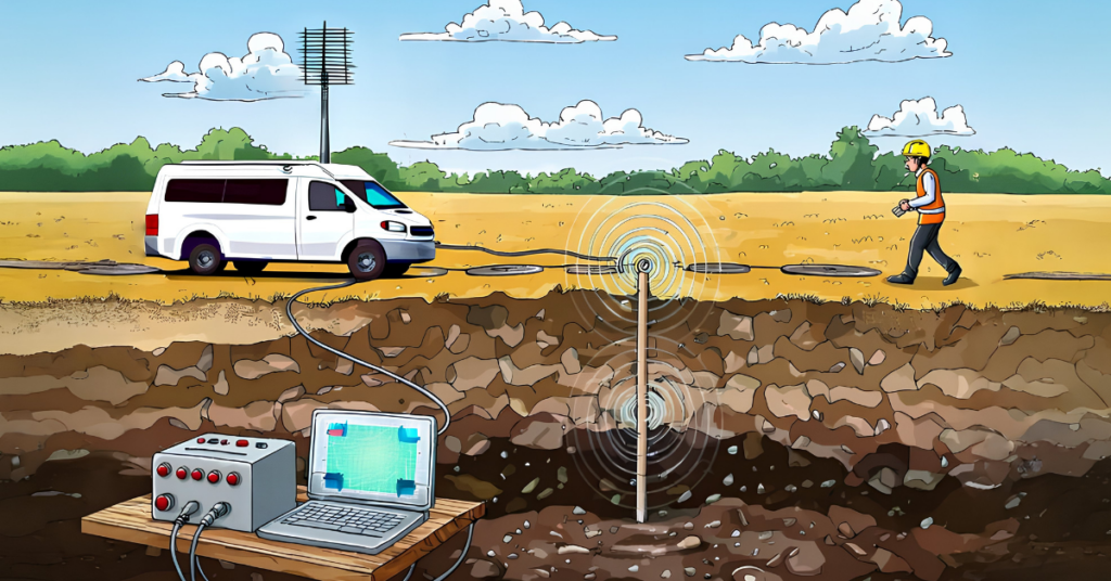
A 3D seismic survey is a method used to map the geology beneath the earth's surface. Small, controlled vibrations or sound waves are sent into the earth and the reflected signals are recorded by sensors called geophones. The data collected is then processed into a detailed 3D image of the subsurface layers. This technology allows geologists to identify potential oil, gas, or other mineral deposits without drilling.
The survey area has been identified as a region of geological interest for oil and gas exploration. Silverthorne Seismic II has obtained the necessary permits to conduct this survey in compliance with Texas state law and applicable regulations. The survey area encompasses a broad region, and your property may fall within or adjacent to the permitted survey boundary.
No. A seismic survey does not transfer, alter, or affect your mineral rights in any way. The survey only collects subsurface data; it does not extract any minerals and creates no claim on your mineral estate. Silverthorne Seismic II has no interest in acquiring, leasing, or encumbering your mineral rights as part of this project. If you have questions about your specific mineral rights, we encourage you to consult with a qualified attorney or landman.
No. The Redtown 3D seismic survey has absolutely no effect on your water rights, water wells, or groundwater sources. The survey does not involve any drilling into water-bearing formations, does not introduce any materials into the ground that could affect water quality, and creates no legal claim of any kind on your water resources. Your water rights remain entirely yours, completely unchanged by this survey.
Possibly. If your property is within the permitted survey area, a Goldstar Land Services representative will contact you in advance to introduce the project, explain what access, if any, is needed, and address any questions or concerns you have before any activity takes place. No work will begin on your property without proper communication first. All survey crews and geoscientists will be clearly identifiable.
Our crews are trained to minimize surface disturbance and to respect private property. We take care to avoid damaging fences, crops, livestock areas, structures, and water features. If any incidental damage does occur as a direct result of our survey activities, Goldstar Land Services has a process for the prompt and fair resolution of claims.
The survey is a temporary, non-invasive activity. It does not place any permanent easement, lien, or encumbrance on your property, and it has no known negative effect on property values. Once the survey is complete, crews remove all equipment and debris and restore the land to its prior condition.
Depending on the method used in your area, equipment may include vibroseis trucks (vehicles that generate controlled ground vibrations) or truck mounted drilling rigs that dig 4 inch diameter boreholes. These boreholes will be infilled after data collection. Both methods are of industry standard and are carefully managed to avoid unnecessary disruption. Care will be taken to establish a safety buffer from all structures and utilities. All methods follow strict state and federal safety regulations.
The duration varies depending on the size of the survey area and field conditions. Goldstar Land Services will provide timeline information specific to your area when their representative contacts you. In most cases, activity near any individual property lasts only a matter of days.
If you've received a permit notice or mailer related to the Redtown project, please contact your Goldstar Land Services representative. If you have lost your notice, you are welcome to contact us using the form below with any questions or concerns.
First, contact your Goldstar Land Services representative. If you do not know your representative, please use the contact form below and be sure to include your name, property address, and a description of your concern. A member of our team will respond.
Yes — please click the "En español" tab at the top of this page for a full Spanish-language version of this content. / Sí — por favor haga clic en la pestaña "En español" en la parte superior de esta página.
Get In Touch
Contact Our Project Team
Whether you have a question, want to report a concern, or need to reach someone before a crew arrives ,we're here. A member of our team will respond as soon as possible. You can also contact your Goldstar Land Services representative directly with questions about permitting or land access.
Project Line
Project Identification & Disclaimer
Goldstar Land Services and Silverthorne Seismic II are currently permitting and acquiring the Redtown 3D seismic project northwest of Lufkin. The Redtown 3D is in no way associated with Redtown Ranch Holdings, LLC. Redtown 3D is a geophysical data acquisition program conducted solely for the purpose of evaluating subsurface geological formations and potential mineral resources for Oil & Gas Exploration. The survey involves non-invasive seismic data acquisition purely focused on the Oil and Gas potential in the Haynesville and Bossier formation and as such is designed to image the subsurface to about 22,000 feet below the surface. The acquisition of this data does not include water extraction nor any activity intended to obtain or affect groundwater or surface water rights.
The Redtown 3D Seismic Project has no interest in acquiring, developing, or influencing water rights. Our Oil & Gas Exploration venture operationally excludes participation with Redtown Ranch Holdings, LLC and any of its business activities, including efforts to acquire or develop water rights. No coordination, joint venture, shared ownership, or common operational control exists between the Redtown 3D seismic project and Redtown Ranch Holdings, LLC with respect to water sourcing, water rights acquisition, or water management.
Accordingly, surface or mineral permitting of the Redtown 3D Seismic Project will not impact, transfer, diminish, or otherwise affect landowners’ groundwater or surface water rights. This project is limited strictly to seismic data acquisition for oil and gas mineral evaluation.